
Trace a Turlock Street by Address
A Turlock street directory search is an address chain. The county Assessor and GIS connect a street address to an APN and a mapped parcel. The recorder then supplies the current owner's indexed documents and, when available, the deed image. Turlock Building & Safety and Planning files add project evidence. Historic directories, census schedules, assessment rolls, and maps may add household context for an earlier period.
Walk the chain in this order, and keep the question narrow. The goal may be the owner at a date, the parcel next door, a permit tied to the site, or a former householder. Each result answers only its own question.
- Normalize the street number, direction, street name, and street type. Check whether the postal city is Turlock and whether the parcel lies inside the incorporated boundary.
- Use county Assessor or GIS resources to obtain the APN, situs address, legal description, and owner of record.
- Search the owner as a grantee in RecorderWorks, then open the instrument and compare the APN or legal description.
- Search the seller backward as an earlier grantee. Treat a deed of trust, release, or reconveyance as a different instrument from a conveyance.
- Use the city permit search, planning records, historical maps, directories, and census material to add dated property or household context.
The finished trail reads as address to APN, APN to owner, owner to deed, deed to earlier party, and then property evidence to historic household evidence. It is more reliable than a street-wide list with no source dates.
Turlock Street Records by Source
Address-keyed records in Turlock come from several keepers. The coverage table distinguishes a mapped parcel from an indexed document and a historic directory line. The public channels documented in the research include online search, county kiosks and counters, city requests, library reference help, CSU archival research, and controlled state tools.
| Record set | Address role | What it can show | Access |
|---|---|---|---|
| Assessor parcel | Situs and APN | Owner, mailing address, values, legal description | Known APN, kiosk, or approved inquiry |
| County GIS | Mapped parcel geometry | Adjacent parcels, city limits, layers, APNs | Free map applications |
| RecorderWorks | Legal description and party | Deeds, liens, document dates, historic locators | Free index; images and copies vary |
| Turlock permits | Project site address or APN | Applicant, owner, contractor, scope, work dates | Issued search or focused city request |
| Controlled voter data | Residence address for approved use | Election registration information | Not a public street browser |
| Reverse directories | House number and street | Listed historic householder | Library or archive; local run unverified |
That last distinction controls the whole Turlock street directory. GIS may show that two parcels touch. The Assessor may identify an owner. A directory may list one householder. None of those sources reliably enumerate everyone connected to the address today.
Note: Address fields identify record roles, not a complete list of people connected to the parcel.
Turlock Assessor Search Limits
The Assessor route is powerful once the APN is known, but the research specifically warns against describing it as a free name-and-street web search. Free Public Inquiry requires a known APN, and public self-service kiosks at 1010 10th Street, Suite 2400 in Modesto expose assessment information. An approved Online Agency Inquiry can search by Parcel Number, Name, Situs, and other fields, but that product costs $300 per year for up to five users and requires a demonstrated business need.
Use the address to find the parcel through GIS or a county contact, then let the APN carry the search. The field inventory below reflects the documented inquiry scope and keeps the owner roll separate from household evidence.
| Field | Type and Turlock use |
|---|---|
| Parcel Number | Text APN; retain the punctuation displayed by the county result. |
| Name | Owner of record in the approved inquiry, not a list of people at the site. |
| Situs | Physical address; spelling, direction, and street type can affect matching. |
| Other or advanced fields | Filters depend on whether the access route is public, kiosk-based, or registered. |
The parcel-card inventory can include APN, situs, owner, owner mailing address, legal description or subdivision, tax-rate area, land and improvement values, total value, characteristics, and assessment-year data. Exemptions may be suppressed or summarized. A parcel card does not reliably show every person connected to the structure.
Read Turlock Situs and Mailing Addresses
A situs address is the physical location used by the Assessor and permit systems. A mailing address is where tax correspondence is sent. They can match, but they can also differ. A different mailing address supports only the limited inference that correspondence goes elsewhere. It does not establish the owner's living arrangement or identify the occupants of the situs.
The legal description is a stronger historic anchor than street wording. It can use a lot, block, subdivision, or metes-and-bounds description. The APN is the Assessor's administrative identifier and can change after a parcel split or merge. When an old deed uses a lot or map reference, compare the description to parcel maps instead of relying on a modern street number alone.
- Parcel
- A mapped tax unit used by the Assessor. One parcel can contain one structure, several structures, or a larger complex.
- Plat or parcel map
- A recorded or assessment map that helps identify lots, boundaries, roads, and subdivision relationships.
- Legal description
- The deed identity for land, which can survive a street-name or number change better than a mailing label.
- Criss-cross directory
- A reverse directory organized by street and number, where available, rather than only by surname.
Use these definitions before comparing a current owner with a historic listing. A matching street number is helpful, but a matching parcel or legal description is stronger.
Note: The free public Assessor route begins with a known APN, not an unrestricted surname search.
Browse Turlock Parcels Along a Block
County GIS supports a street-by-street view without promising a resident roster. Search the target address or APN, zoom to the parcel boundary, select its polygon, and note the adjoining APNs. Click each bordering polygon and follow any assessor or property link shown. If a buffer tool is not available, pan and select parcels one at a time.
The county mapping announcement describes layers for city limits and annexations, council districts, transportation, parcels and land assessments, fire districts, county islands, unincorporated areas, and projects. The research could not verify the current popup fields, layer buttons, or radius controls from the landing page. Describe the method as parcel selection, not as a guaranteed radius report.
Multi-unit parcels can collapse many households into one ownership entity. Adjacent-owner evidence is therefore different from evidence about the people who spend time at the address. The Turlock neighbor lookup page handles the immediate block and community layer, while this Turlock street directory stays focused on the named street and its address chain.
A street map is best used to check jurisdiction, parcel continuity, and the next record custodian. It is not a license to publish sensitive details about people who are not identified by the record itself.
Move from APN to a Turlock Deed
RecorderWorks is indexed by name, document number, and book and page rather than by a modern street-wide address search. Translate the street address to the current owner and APN first. Search that owner as grantee within a likely acquisition period. Open the deed, compare the legal description, then write down the grantor. Search the grantor as a former grantee to continue backward.
A grantor is the party transferring, assigning, or releasing an interest. A grantee receives that interest. On a deed of trust, the roles can describe a financing obligation rather than a sale. A reconveyance clears an encumbrance. These distinctions matter when a Turlock street directory search is trying to identify past owners rather than merely collect every indexed name.
The RecorderWorks official index advertises 1850 to present by name. The counter guide adds computer images generally from 1978 forward, a 1920 to 1988 grantor/grantee terminal, and film or fiche back to 1853. Older entries may need a volume, book, and page locator, and copy or document-location fees apply.
The recorded-document screen below is useful for checking the county search path.
Read the Stanislaus grantor and grantee search guidance.
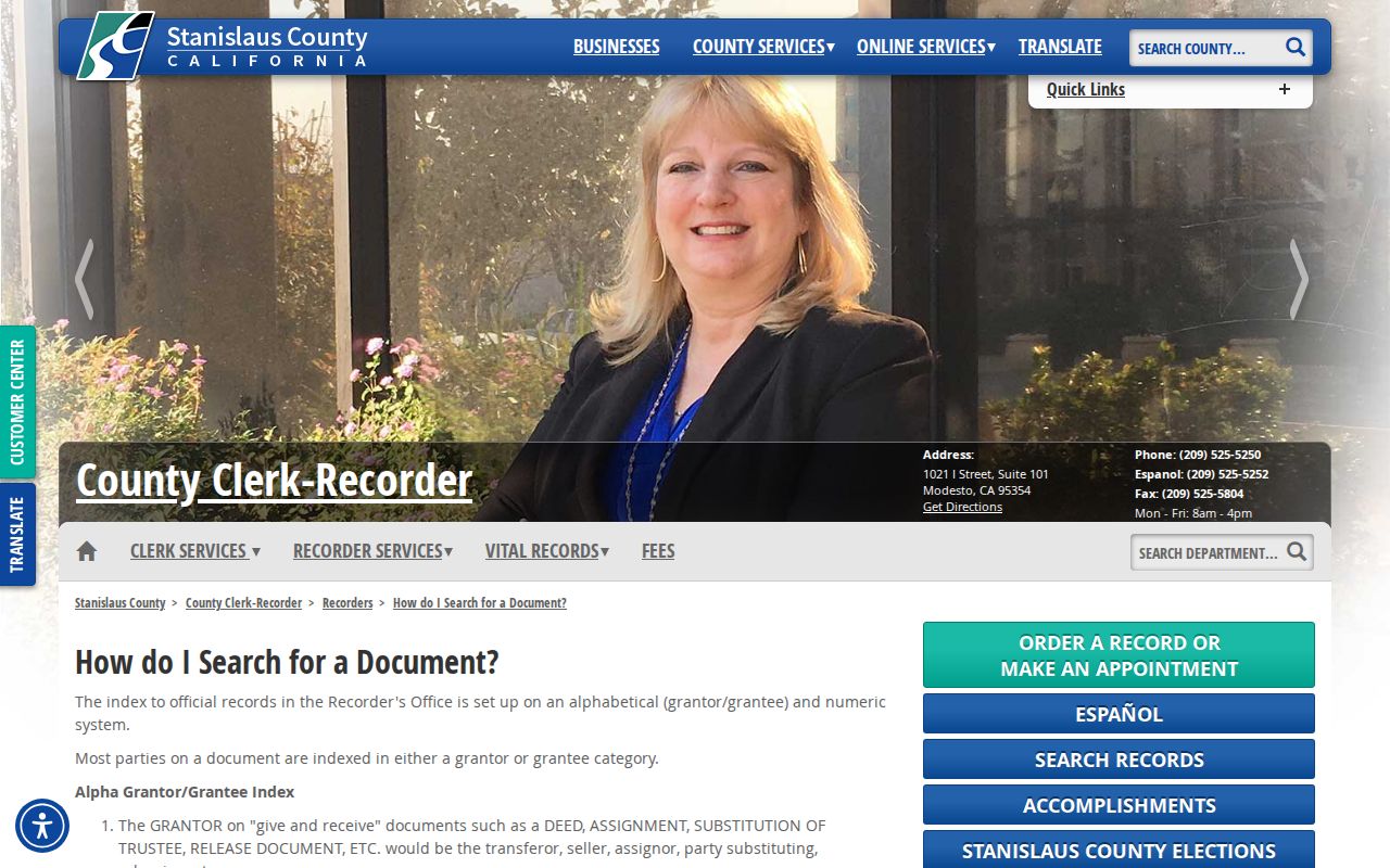
The image points to the role-based index mechanics, while the APN and deed description establish whether the indexed party belongs to the parcel in question.
Turlock Permit Files Add Project Context
Turlock Building & Safety and Planning records can show what changed at an address. The issued-permit search has Search by Address and Search by APN tabs. Address mode asks for Street Number and Street Name and can return a normalized address and APN. A permit file may identify an applicant, owner, contractor, scope, valuation, permit number, issue date, final date, or parcel. It remains evidence about a project, not proof of who occupied the site.
The city also says there is no limitations period for illegal construction and that a transfer of ownership does not legalize it. An old code or permit file can therefore matter to a long-running alteration even after several deeds. Open matters, complainant details, security data, and law-enforcement material may be withheld or redacted.
The Turlock issued-permit search supplies the address and APN route. The research does not establish the individual-search starting year, so the absence of a result should not be reported as proof that no older permit exists.
Permit search fields are visible in the image below.
Open the official Turlock building-permit research tool.
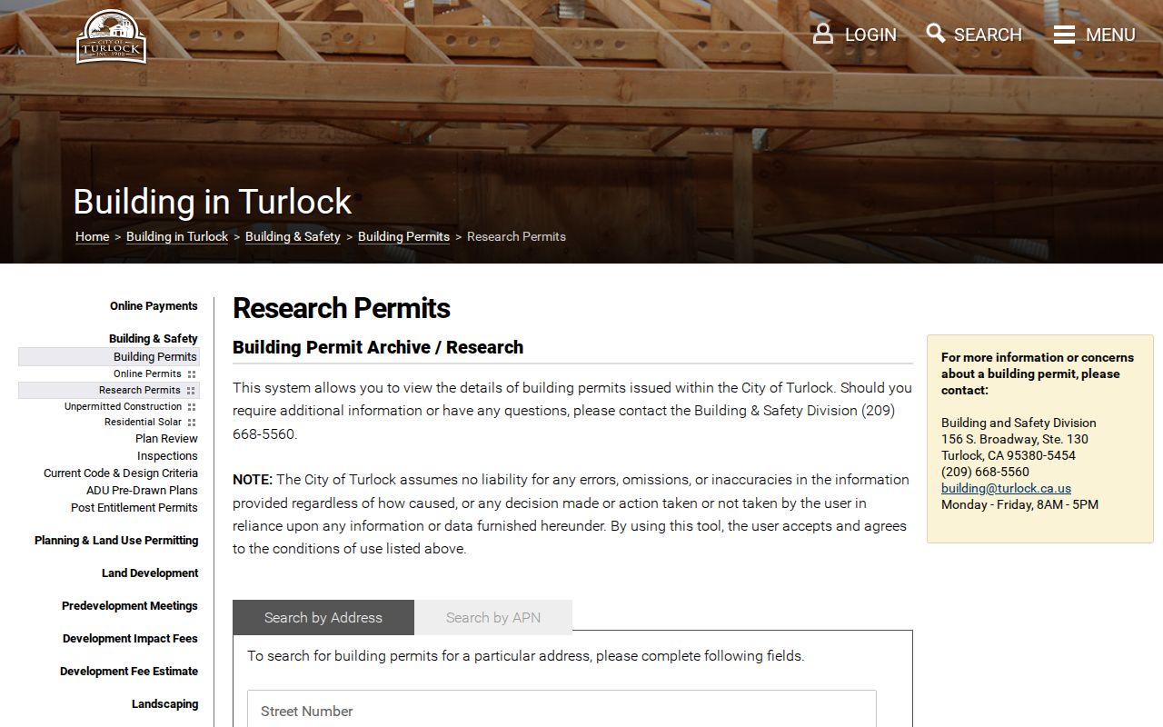
A permit result adds a dated project participant to the address trail, but the surrounding deed, parcel, and household evidence still needs separate review.
The department landing page supplies broader building and planning context for a Turlock address.
Open Turlock Building & Safety services.

Use the department information to choose a request route, then ask for a specific address or APN file rather than a broad resident list.
The city Building & Safety office is at 156 S Broadway, Suite 130; the researched contact is (209) 668-5560, building@turlock.ca.gov, weekdays 8 to 5. A focused request can ask for historic files by address or APN.
Bridge Turlock Streets with Old Maps
Historic street work in Turlock needs a map bridge. CSU Stanislaus Special Collections holds a Turlock map series dated 1903 to 1972. The series can help align old street names, boundaries, lot shapes, and numbering context with assessment rolls, deeds, directories, and the 1913 local census.
No official source in the research establishes a citywide street-renumbering event or year. That gap should be handled as a check, not filled with a guessed date. Compare the map series, nearby cross streets, subdivision references, and the legal description before concluding that two differently written addresses are the same place.
The map series is especially useful around older downtown fabric. Turlock history records major downtown fires in 1893 and 1907, but the research does not say that county record books were destroyed. Pair the 1888, 1891, 1896, 1905, 1907, 1910, 1912, 1922, and 1945 updated Sanborn editions with the map series to study building footprints and uses, not to infer occupant names.
A map can keep a Turlock street directory from losing a household trail when the street label changed. It cannot by itself prove who lived in a building.
Note: Turlock research does not establish a single citywide street-renumbering year, so map comparison remains essential.
Reverse Directories on Historic Turlock Streets
A reverse or criss-cross directory is the historic address angle: house numbers and streets lead to listed occupants. The exact Turlock printed run and local abbreviation key were not located in official public sources. The Stanislaus County Library is the right reference channel to ask about Turlock, Modesto-Turlock, Stanislaus County, telephone, and reverse-directory variants.
CSU Special Collections adds substitutes when a printed volume is missing. Turlock assessment rolls cover 1908 to 1954, personal-property lists cover 1934 to 1935, 1939 to 1940, and 1954 to 1955, and the 1913 local census can bridge federal schedules. Those records identify taxpayers or households in a defined year. They do not guarantee a complete street roster.
Use a known address and year, record the entry exactly, check the closest earlier and later volumes, then compare it with the map series and a census or assessment roll. An absence can reflect a missing publication, rural delivery, spouse-only listing, indexing variation, or a move. The Turlock city directory collections page handles the historical shelf in depth.
The street directory is therefore both modern and historical, but its proof changes with the source. Current parcels require APN and deed checks. Older addresses require maps, directory context, and a dated household source.
Turlock Postal City and City Limits
A Turlock mailing city does not guarantee that a parcel lies inside incorporated Turlock. The research identifies 95380 as a broad southern and central delivery area and 95382 as a broad northern and CSU-area delivery area. It also lists 95381 for Turlock without establishing its precise delivery function. Do not call 95381 a neighborhood, PO-box-only ZIP, or unique-institution ZIP without address-level confirmation.
Use USPS to verify one address, then use county GIS to check the city-limit and annexation layers. A postal city, a situs address, and a legal jurisdiction can be different labels. That distinction decides whether a permit belongs to the City of Turlock, whether a county island is involved, and which public-records office should receive a request.
The Turlock ZIP code lookup page owns the postal geography. This street directory uses ZIP only as a routing clue before returning to parcel and address records.
What a Turlock Street Directory Cannot Show
A street directory cannot reliably list every person connected to a parcel. The Assessor roll identifies an owner of record. GIS identifies geometry. A deed identifies parties to an instrument. A permit identifies project participants. A historic reverse directory identifies a listed householder for a publication year. A controlled voter file is not an open street browser, and protected addresses can be withheld.
Utility customer information, delivery data, DMV addresses, confidential voter addresses, and most household relationships remain outside the ordinary address search. A person can also be absent because a record is sealed, redacted, not yet indexed, held by another jurisdiction, or simply outside the source's purpose.
Report the result with its role and date: “owner of record in the searched assessment source,” “permit applicant on the listed file,” or “historic householder in the inspected directory.” That plain wording protects accuracy and prevents a street directory search from becoming an unsupported claim about a living person.
Note: A street directory result should carry its source date and relationship label before it is shared.